Neighborhood Map
See what is near any US address.
Search an address or a place and get an interactive map of the parks, transit, grocery stores, cafés, schools and health care nearby, with straight-line distances and walking minutes. Free to try, drawn from OpenStreetMap data.
Try it
Your map, in under a minute.
Below is our fictional Kirkland sample. Search any place in the USA to make your own. Tap a number to see the place, the distance and the walking time.
For your listing
The checked version, ready to publish.
Maps made on this page are automatic and not checked by a person. For marketing, order the reviewed version: we check every place, name and distance, then add it to your listing pack.
- Checked by a personEvery place, name and distance is checked against the map data before delivery.
- Your brandingYour name, brokerage, logo and colours, matched to your brochure style.
- Print-ready PDFA one-page, letter-size map with the numbered “What’s nearby” key.
- Social imageA 1080×1350 image sized for Instagram and Facebook feeds.
- QR code to the interactive mapBuyers scan the flyer or sign and explore the map on their phone.
- Added to your listing packDelivered with your brochure, property page and social posts.
Neighborhood map
Included in every listing pack
Essential from $149 per listing
Facts and straight-line distances only, in line with fair housing rules. Schools are shown as locations only.
Order a pack with the checked map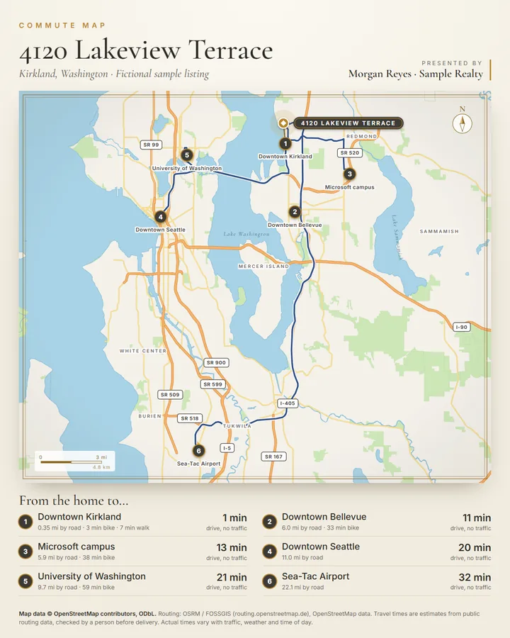
Also available
Commute map: from the home to work and the airport.
A regional map with the road route from the home to job centres and Sea-Tac Airport, plus a table of road distances and estimated drive, bike and walk times. Drive times are typical times without traffic; rush-hour and transit times on request. Checked by a person before delivery.
Example price
$39 per listing, on its own or added to any listing pack.
The fine print
How the map is made.
- Map data © OpenStreetMap contributors, ODbL. The map is drawn by us from OpenStreetMap data. No Google, no map tiles.
- Distances are straight-line estimates from public map data. Not a survey. Walking minutes assume 80 m (262 ft) per minute in a straight line. They are not routes or commute times.
- Not checked by a person — order the reviewed version for marketing use. Maps you make on this page are automatic. Places can be missing, closed or named differently in the map data.
- Facts only. The map lists places and distances. It does not describe or score the area, and schools are shown as locations only.
- Private by design. Your search goes from your browser to OpenStreetMap’s Nominatim and Overpass services and is kept only in this browser tab. To keep the free services fair, you can make one new map every 20 seconds.